Difference between revisions of "Tri-Cities Upcoming Projects"
Jump to navigation
Jump to search
| Line 5: | Line 5: | ||
'''Click the map to get to an interactive version!''' |
'''Click the map to get to an interactive version!''' |
||
| − | [[File: |
+ | [[File:HUB_TriCities_Upcoming_Projects_March_21_2023.jpg| border | 500px | link=https://www.google.com/maps/d/u/1/edit?mid=1AFXnV_S-5mQcAerJzc2CQkkQUeckspAU&usp=sharing]] |
'''''Please note: this list only covers projects funded by municipalities and governments. Projects built through property redevelopment are not shown on this list. For information on all civic projects, please check municipal websites. In addition, due to changing project schedules, projects are often subject to delay''''' |
'''''Please note: this list only covers projects funded by municipalities and governments. Projects built through property redevelopment are not shown on this list. For information on all civic projects, please check municipal websites. In addition, due to changing project schedules, projects are often subject to delay''''' |
||
Revision as of 12:34, 21 March 2023
Return to Tri-Cities Committee Wiki
Click the map to get to an interactive version!
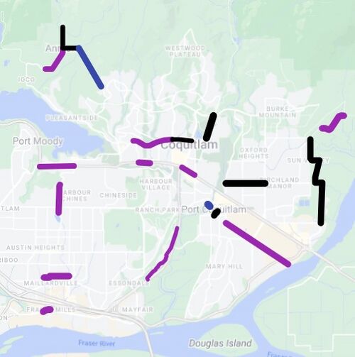
Please note: this list only covers projects funded by municipalities and governments. Projects built through property redevelopment are not shown on this list. For information on all civic projects, please check municipal websites. In addition, due to changing project schedules, projects are often subject to delay
- 2023 projects are in purple
- 2024 projects are in black
- 2026 projects are in royal blue
Coquitlam
2023:
- Gatensbury Street multi-use path from the Port Moody border to Regan Street
- Signage through the Sumiqwuelu site (formerly Riverview)
- Lougheed Highway multi-use path between Pinetree Way and Westwood Street on the north side of the roadway
- Guildford Way protected bike lanes from Johnson Street to the Port Moody border
- New Strategic Transportation Plan
- United Boulevard multi-use path from King Edward Overpass west to existing terminus near New Westminster
- Barnet Highway eastbound protected bike lane from Falcon Drive to Bond Street
- Maillardville Greenway along Cartier Avenue from Schoolhouse Street to Marmont Street, then down Marmont Street to Quadling Avenue and west to Nelson Street
- Cedar Drive multi-use path from 4180 Cedar Drive to Gilley's Trail
2024:
- Pipeline Road multi-use path from David Avenue to Guildford Way along the west side, with new pedestrian lighting
- Fremont Connector and adjacent multi-use path
- Guildford Way protected bike lanes from Johnson Street to Pinetree Way
Port Moody
2023:
- St Johns Street multi-use pathway from Moody Street to Barnet Highway
- Trail Network Plan, including expansion, classification, standardization of signage, and more
Port Coquitlam
2023:
- Kingsway Avenue multi-use path between Tyner Street and Kebet Way
2024:
- Donald Street Pathway between Wilson Avenue and McAllister Avenue
- Prairie Avenue multi-use path between Coast Meridian Road and Shaughnessy Street
- Fremont Connector and adjacent multi-use path
2025
- McAllister Avenue footbridge over the Coquitlam River (built to 4m width)
Belcarra
No projects funded.
Anmore
2023:
- Sunnyside Road multi-use path between East Road and (roughly) 2014 Sunnyside Road
2024:
- East Road multi-use path between (roughly) 2285 East Road and Sunnyside Road
- Sunnyside Road multi-use path between East Road and Alpine Drive
2026:
- East Road multi-use path between (roughly) 2285 East Road and 1343 East Road