Difference between revisions of "Burnaby Committee Ride Ideas"
SebastianE (talk | contribs) (Add link to Lets go biking) |
SebastianE (talk | contribs) (Add BC Parkway ride) |
||
| Line 25: | Line 25: | ||
|0:33 |
|0:33 |
||
|[[File:TinyMapFraserForeshore.png|link=https://www.komoot.com/tour/1092503059|Route information]] |
|[[File:TinyMapFraserForeshore.png|link=https://www.komoot.com/tour/1092503059|Route information]] |
||
| + | |- |
||
| + | | BC Parkway |
||
| + | |||
| + | Fairly easy loop along the BC parkway and a multi-use path on Rumble St |
||
| + | |17.7km |
||
| + | |130m |
||
| + | |1:06 |
||
| + | |[[File:RumbleBCPkwy.png|link=https://www.komoot.com/tour/1416700368|Route information]] |
||
|} |
|} |
||
Latest revision as of 23:28, 16 January 2024
This is a collection of particularly enjoyable bike rides of different lengths and levels of difficulty. Every ride here was done at least once by a member of the Burnaby Local Committee, who felt it was nice enough to share with others. Nevertheless, the route may include uncomfortable sections and road conditions could have changed by the time you get there, so please be prepared to adjust the route where needed. Also check out the rides suggested by Let's Go Biking.
| Description | Length | Ascend | Time | Map (click for details) |
|---|---|---|---|---|
| Burnaby Mountain loop
Lakes route up to Burnaby Mountain, nice view from Centennial Way, Trans Canada trail around the mountain, down along Stoney Creek to Cariboo and back up to Lakes. Temporary construction detour (2023): take Lougheed Hwy and Brighton Ave to Government Road. |
26.6km | 470m | 2:27 | 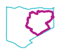
|
| Fraser Foreshore
Flat, relaxed ride on a shared path along the river in a park. Cafe and playground by Kerr St. |
7.6km | 10m | 0:33 | 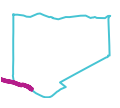
|
| BC Parkway
Fairly easy loop along the BC parkway and a multi-use path on Rumble St |
17.7km | 130m | 1:06 | 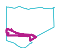
|