Difference between revisions of "HUB Tri-Cities Gaps - Full List"
| Line 2: | Line 2: | ||
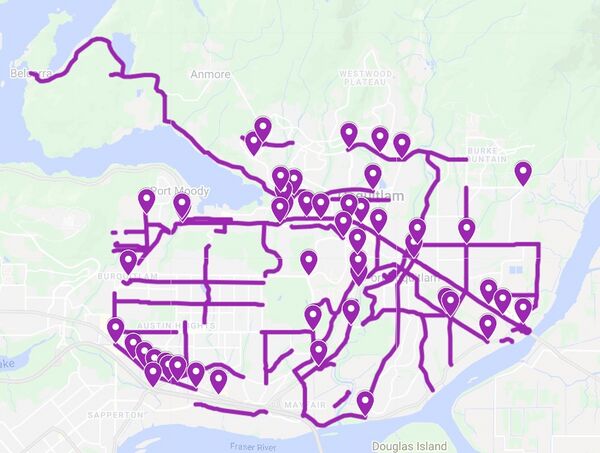
Our gap map for the entire subregion. The map is clickable and leads to an interactive map (please note, you may need to turn off the green, orange, and yellow layers, which indicate route comfort levels). Points represent bad intersections, and lines represent bad segments. Finalized February 15, 2022. |
Our gap map for the entire subregion. The map is clickable and leads to an interactive map (please note, you may need to turn off the green, orange, and yellow layers, which indicate route comfort levels). Points represent bad intersections, and lines represent bad segments. Finalized February 15, 2022. |
||
| + | |||
| + | Notes |
||
| + | -List is not exhaustive. HUB Cycling is lobbying for many other policies, bylaws, and changes (such as speed limit reductions) to make biking safer |
||
| + | -List is based off of constraints, such as municipal budgets and topographical challenges that will persist until ebikes become more widely used |
||
| + | -Gaps range from lighting upgrades to intersection rebuilds and installation of protected bike lanes and multi-use paths |
||
[[File: Gap_Map_Feb_15_2022.jpg | border | center | 600px | link=https://www.google.com/maps/d/u/1/viewer?hl=en&mid=1wlQVVmwJBDBVMZt2S5-5Ts5z9unilKHJ&ll=49.27295615404833%2C-122.79334425211185&z=12]] |
[[File: Gap_Map_Feb_15_2022.jpg | border | center | 600px | link=https://www.google.com/maps/d/u/1/viewer?hl=en&mid=1wlQVVmwJBDBVMZt2S5-5Ts5z9unilKHJ&ll=49.27295615404833%2C-122.79334425211185&z=12]] |
||
Revision as of 17:42, 15 February 2022
Return to Tri-Cities Committee Wiki
Our gap map for the entire subregion. The map is clickable and leads to an interactive map (please note, you may need to turn off the green, orange, and yellow layers, which indicate route comfort levels). Points represent bad intersections, and lines represent bad segments. Finalized February 15, 2022.
Notes -List is not exhaustive. HUB Cycling is lobbying for many other policies, bylaws, and changes (such as speed limit reductions) to make biking safer -List is based off of constraints, such as municipal budgets and topographical challenges that will persist until ebikes become more widely used -Gaps range from lighting upgrades to intersection rebuilds and installation of protected bike lanes and multi-use paths