Difference between revisions of "Hot Spots"
imported>Antje Wahl |
imported>Antje Wahl |
||
| Line 172: | Line 172: | ||
=== Lillooet Road === |
=== Lillooet Road === |
||
| + | |||
| ⚫ | |||
'''Location:''' |
'''Location:''' |
||
| Line 191: | Line 193: | ||
'''Responsible Bodies:''' |
'''Responsible Bodies:''' |
||
* DNV |
* DNV |
||
| − | |||
| − | '''Status:''' |
||
| ⚫ | |||
---- |
---- |
||
Revision as of 12:10, 4 October 2011
The Hot Spots page is a collection of specific locations throughout the North Shore where improvements are needed.
District of North Vancouver
Welch Street & Bridge Road Improvements

Location:
Bridge Road east from Park Royal through Bridge Road and Welch Street into North Vancouver
Issues:
The DWV is working with the Squamish Nation about incorporating the Spirit Trail from Park Royal along Bridge Road, then along Welch Street into North Vancouver. In addition to the Spirit Trail, there will be possible enhancements to the roadway, a controlled intersection at Lower Capilano Road and Welch Street. The issues are:
- Make sure that in addition to the Spirit Trail there are provisions made for commuter cyclists and road riders (e.g. bike routes north/south on Bridge Road, east/west on Welch Street)
- Make sure there are provisions for bikers to activate the “controlled signals” at the intersection of Lower Capilano Road and Welch Street
- Improved paving to eliminate the pot-holes and cracks that currently exist
- Widen the road way to make it easier for cars and cyclist to co-exist
- Ensure DNV embraces the changes made on Bridge St, Bridge Rd and Welch St and continue these improvements into North Vancouver
NS-VACC Objectives:
- Advocate for the proper resolution of the issues above.
Responsible Bodies:
- DNV
Capilano Road Improvements (completed)

Location:
Capilano Road between Fullerton and Hwy 1
Issue:
- Construction is now completed
- Highlights of the project include (taken from the web site at http://www.dnv.org/capilanoroad)"
- Reduction of a sharp curve in the roadway, which will reduce the risk of collisions and promote more consistent travel speeds;
- Addition of standard street lighting to improve visibility for all users;
- Installation of a traffic signal at 21st Street to facilitate safer vehicle access, allow for safer pedestrian crossings, and facilitate signal coordination;
- Reconstruction and widening of sidewalks on the east side, and construction of sidewalks at key locations on the west side;
- Construction of separate bicycle lanes on both sides of Capilano Road to reduce conflicts between drivers and cyclists and ensure safer travel for cyclists;
- Replacement of sections of storm sewers and watermains underneath Capilano Road; and
- Rehabilitation of the pavement along the roadway.
NS-VACC Objectives:
- Issue closed
Responsible Bodies:
- DNV
Marine Drive: Lions Gate to Bewicke
Location:
description and google map?
Issue:
What is wrong?
NS-VACC Objectives:
- Lions Gate to Capilano Road construction is now completed
What else is required?
Responsible Bodies:
- DNV
- BC MOTI
Access from Pemberton Heights to Capilano Rd


Location:
Keith Rd and the Hwy 1 access ramp to Capilano Rd.
Issue:
Residents of Pemberton Heights do not have a safe means to access Capilano Road. The steep escarpment on the south perimeter of the area prohibits direct access to Marine Dr and points beyond. The only reasonable cycling accesses for Pemberton Heights are Mackay Ave on the east and the Highway 1 ramp to Capilano Road on the west. Enhancing access here would also open up cycling routes utilizing the Phillip Ave tunnel, the Pemberton overpass and the path along the south side of the highway from Lloyd Ave to Mosquito Creek.
NS-VACC Objectives:
- Continuation of the northbound cycling lane on Capilano Rd as a multi-use pathway to W Keith Rd and 23rd St
- Zebra at intersection of 23rd and Keith Rd to facilitate crossing from the proposed MUP to the trail to 23rd st
- Painted cycle lanes on W Keith Rd
- Curb drops at either end of the trail to 23rd St to facilitate use by cyclists
- Cyclist accessible signal button and crossing at south side of intersection on Capilano Road for access to/from the southbound cycling lane on Capilano Road.
Discussion
- Jay MacDonald has had several conversations with Patrick Golier of DNV regarding access between Pemberton Heights and Capilano Rd.
Responsible Bodies:
- DNV
- BC MOTI
Spirit Trail at Mosquito Ck
Location:
description and google map?
Issue:
- What is wrong?
NS-VACC Objectives:
What do we advocate for it?
Responsible Bodies:
- DNV
Trail between Tatlow Ave and Capilano Rd

Location:
At the north end of Tatlow Ave is a convenient trail that connects to Capilano Road opposite Graveley St. The trail is rumoured to be off limits to bicycles (certainly the trail east of Tatlow is, and is signed as such). This is a perfect connector for bicycle traffic coming from Marine Drive to Capilano Road.
Issue:
- Need to confirm that this is not off limits to bicycles. If so this is just a short cut.
- Access to the trail from Graveley St requires crossing Capilano Rd at a busy spot. A signal or a tunnel would help.
NS-VACC Objectives:
- Sign and maintain it as a bike route
- Safe crossing of Capilano Rd
Responsible Bodies:
- DNV
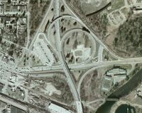
Lillooet Road
- Construction of Lillooet Road bike path is underway (fall 2011)
Location:
- Lillooet Road is the main access road for traffic headed for Capilano University, the residential neighbourhood next to the university, and the LSCR.
Issues:
- Speeding is common, especially during school rush hour.
- When going north and uphill, most commuter cyclists use the east sidewalk along Lillooet Road.
- No bike lane at intersection with Purcell Way (north bound). On-road cyclists use the right turn lane to go straight (not legal) because they don't want to block the other lane while going uphill at a slow speed.
- When going south and downhill, it can be difficult for cyclists to find the correct position on the road because the number and width of the lanes varies between Purcell Way and Mt Seymour Parkway.
- When going south, the painted bike symbols between Inter River Road and Purcell Way are located too close to the parked cars.
- Insufficient signage to connecting bike routes, Capilano University and the LSCR.
NS-VACC Objectives:
- For northbound (uphill) cyclists: Separate paved bike path along Lillooet Rd from Mt Seymour Parkway to Purcell Way; more sharrows between Purcell Way and cemetery entrance.
- For southbound (downhill) cyclists: Sharrows on Lillooet Rd between Purcell Way and Mt Seymour Parkway; more sharrows (correctly placed) between cemetery and Purcell Way.
- Signage to destinations and other bike routes
Responsible Bodies:
- DNV
Old Lillooet Road
Location:
- Old Lillooet Road is the shortest route between Capilano University, the Lynnmour neighbourhood and shops & services on Main St, at Park & Tilford and west-bound bike routes.
Issues:
- No convenient connection for cyclists between the north end of Old Lillooet Rd and Lillooet Rd
- No signage
NS-VACC Objectives:
- Paved bike path with curb drops between the north end of Old Lillooet Rd and Lillooet Rd.
- Facilitate crossing of Lillooet Rd near north end of Old Lillooet Rd.
- Signage to destinations and other bike routes, especially to the bridge underpasses at Hwy 1 and Keith Rd.
Responsible Bodies:
- DNV
Keith Bridge and Highway 1 underpasses at Lynn Creek
Location:
- The east side bridge underpasses connect East Keith Rd at Mountain Highway with Old Lillooet Road.
Issues:
- Path not paved and too narrow under Keith bridge.
- No cycling infrastructure south of the underpasses at Mountain Highway and Keith Rd. Cyclists are left to either ride the arterial roads or use sidewalks. There is a crushed gravel path partway through Seylynn park, but it does not connect, interferes with the skate park users and has bad surface quality.
- No signage.
NS-VACC Objectives:
- Paving, widening of bridge underpasses at Lynn Creek.
- Add cycling infrastructure south of bridge underpasses:
- Bike path or lane connecting the Hwy 1 underpass with Orwell St.
- Bike lanes on East Keith Rd.
- Wide multi-use path through Seylynn Park and along Lynn Ck to Main St.
- Signage to destinations and other bike routes.
Responsible Bodies:
- DNV
Fern Street / Mountain Highway
Location:
- Fern St between Hwy 1 overpass and Mountain Highway; Mountain Highway between Fern St and East Keith Rd.
Issues:
- Arterial roads due to be widened for highrise development on Fern St.
- No safe bike route available that connects from Orwell St to E Keith Rd or Lynnmour North (north of Hwy 1).
NS-VACC Objectives:
- Infrastructure needed for safe and convenient north-south connection (Orwell St to E Keith Rd and bridge underpasses) and east-west connection (Mountain Highway to Mount Seymour Parkway/Superstore area)
- Place push button at existing Fern St crosswalk (at Orwell ramp) so it is not hidden, or add a sign.
Responsible Bodies:
- DNV
- BC MOTI
Orwell Street
Location:
- Between the park & ride lot at Phibbs exchange to the south and Fern St to the north.
- Orwell St is a quiet off road alternative to Mountain Highway with almost no car traffic.
Issues:
- Curbs across path need to be removed
- Bad path surface
- Trail too narrow in places
- Cars park across path entrances
NS-VACC Objectives:
- Paved multi-use path along Orwell St
- Signage
Responsible Bodies:
- DNV
Seymour Greenway
Location:
- The Seymour Greenway will connect the LSCR with the waterfront, broadly following the Seymour Valley. It will be a multi-use path (pedestrians, cyclists, horses in the upper area).
- Construction of the section between the cemetery and Mount Seymour Parkway started in October 2010 and is largely completed.


Issues:
- The greenway has the potential to improve access to Capilano University, the LSCR and the residences in the area, at least during day time. The hydro right-of-way route south of Capilano University will probably feel too isolated for many commuter cyclists.
NS-VACC Objectives:
- Connect well with bike routes on Mount Seymour Parkway and Lillooet Rd.
- Signage to destinations and bike routes.
- Supplement but not substitute for a paved bike path to Capilano University.
Responsible Bodies:
- DNV
Mt Seymour Parkway / Seymour Boulevard intersection
Location:
- Intersection of Mt Seymour Parkway and Seymour Blvd (next to Superstore)
Issues:
- Almost impossible to cross Mt Seymour Parkway on Seymour Blvd. When going east on bike path along Mt Seymour Parkway, the path ends shortly before Seymour Blvd. Cyclists need to walk bikes across three pedestrian crosswalks to get to the south side of Mt Seymour Parkway.
NS-VACC Objectives:
- Install cyclist push button or camera so cyclists can trigger light.
Responsible Bodies:
- BC MOTI
- DNV
Iron Workers Memorial (Second Narrows) Bridge
Location:
- Major connector route along Highway 1 between North Vancouver and Vancouver/Burnaby over Burrard Inlet.
Issues:
- Sidewalks are very narrow.
- Two cyclists going into the same direction cannot pass, which is a problem given the length and elevation gain of the bridge.
- Two way cycling is allowed where two cyclists or a cyclist and a pedestrian can't safely pass.
- Approaches and exits are dangerous and difficult.
- Way-finding signage to and from bridge is insufficient.
==> More details and background information are available on this page.
NS-VACC Objectives:
- Wider riding path that allows cyclists to pass.
- Improved infrastructure to accommodate cyclists from all directions to safely reach objectives
- Better way-finding signage.
Responsible Bodies:
- BC MOTI
- District of North Vancouver (DNV)
- City of Vancouver (COV)
Aerial view of North End
Aerial view of South End
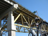
Looking up from North West end underneath IWMB


Overpass over Hwy 1 at Lynn Valley
Location:
- Lynn Valley Rd crosses under Hwy 1.
Issues:
- Getting from Lynn Valley to south of the Upper Levels Highway is difficult and dangerous.
NS-VACC Objectives:
- A safe and easy route is needed, preferably an overpass.
Responsible Bodies:
- DNV
- CNV
- BC MOTI
City of North Vancouver
Low Level Road
Location:
- Low Level Road is a key section of the fairly flat east-west bike route through North Vancouver
- Low Level Road runs along the railway tracks and the waterfront escarpment, between Cotton Drive in the east and Esplanade in the west
Issues:
- Port Metro Vancouver plans to raise and realign Low Level Road. The public consultation guide is on the Port Metro Vancouver website
- Project would eliminate water pooling and widen bike lanes
- But Low Level Road would not be 'low level' anymore
- Traffic speed may increase after realignment
NS-VACC Objectives: Please see the attached .pdf file for a full documentation of our response to the public consultation hosted by CNV and Port Metro Vancouver.
The Low Level Road project objectives include increasing truck access to rail and marine terminals to facilitate increased importing and exporting goods. In addition, new train tracks with more capacity and increased marine transportation are planned. While contributing to economic growth, increases in all these forms of transportation will also contribute to increased air pollution, noise and truck traffic through our community.
As well as being committed to economic growth the provincial, federal and municipal governments are all advocates of reducing green house gas emissions and promoting active transportation as part of their long term plans for healthier communities.
The VACC - North Shore Committee recommends, the organizations and governments involved in the North Shore Trade Plan take this as an opportunity to implement the first ever, purpose-built, flat, safe, well-lit, regularly maintained bike route on the North Shore.
$273 million taxpayer dollars will be spent on the six proposed improvements to the roadway to increase motor vehicle flow and truck access to port and rail facilities. Surely we can find the money to engineer a better way to accommodate cyclists on a flat, safe, well-lit, regularly maintained, route across the North Shore.
Feedback to the Low Level Road Project
Presentation to Council April 18, 2011
Responsible Bodies:
- CNV
- Port Metro Vancouver
Signal at Lonsdale and 27th


Location:
Intersection of Lonsdale Ave and 27th St
Issue:
- 27th St is a designated bicycle route but the signal is only accessible to pedestrians on the north side of 27th St. If you are east bound on a bicycle then you must either chance a crossing on a notoriously busy street or cross 27th and ride up on the sidewalk to access the signal. This is dangerous and inconvenient.
NS-VACC Objectives:
- Need a bike accessible signal button or sweet spot on the south side of 27th
Discussion
- This was introduced and briefly discussed at the March 2010 JBAC meeting. Response was "...that the City cannot afford this as a Capital item, but it could be done if there is re-development in the vicinity or when the lights need refurbishment."
Responsible Bodies:
- CNV
Two-way Cycling on 25th St

Location:
25th St next to the Upper Levels between Ridgeway Ave and Westview Dr
Issue:
- 25th St is a perfect connector between Westview Dr and the trail between Tempe Glen and 25th. Current designated bike route diverts to 27th which takes the rider several blocks out of his way and introduces hills.
- Creating a proper 2-way bike lane along 25th St makes the most sense for a connector route between Lynn Valley and Westview centres, which is one of the objectives of the Official Community Plan.
NS-VACC Objectives:
- Lobby to get 2-way bike lanes along 25th St
Discussion
- This was discussed at the March 2010 JBAC meeting. The response was "...the City staff have been looking at this already and some designs are being drafted up."
- Jay MacDonald contact Daniel Watson at the City regarding the plans. Response was "We’re still in the conceptual design phase for west 25th Street and haven’t yet secured any capital funds allocated towards the project. I would like to hear your ideas though, if you have time please pass them on and we can add them to the mix."
Responsible Bodies:
- CNV
- BC MOTI
Trail Connecting Tempe Glen Dr and 25th St (aka Bark Mulch Trail)

Location:
Between Tempe Glen Dr and 25th St next to the Upper Levels
Issue:
- The trail can get really muddy, overgrown and dangerous.
- Is part of a dedicated cycling route on the 2006 Bicycle Master Plan
NS-VACC Objectives:
- Needs to be improved, preferably with a gravel road grade or paved.
- Regular pruning back of vegetation is needed.
- Access at west end requires sidewalk riding - advocate for curb drops to enhance access.
Responsible Bodies:
- BC MOTI
East Keith Road
Location:
- East Keith Road between Grand Boulevard and Mountain Highway (west of Keith bridge across Lynn Creek)
- Construction is underway as of 14 Sept 2011
Issues:
- No direct bike route exists between Lynnmour, Keith-Lynn and Central Lonsdale
NS-VACC Objectives:
- Bike lanes on East Keith Rd between Lynn Creek and Hendry Ave (westbound will be a dedicated lane, eastbound will be a shared lane)
- Bike lanes and bike boxes at the following intersections:
- Keith Rd and Mountain Highway
- Keith Rd and Brooksbank Ave
- Continuation of bike route west to Marine Drive
Responsible Bodies:
- CNV
- DNV
Brooksbank Ave
Location:
- Brooksbank Ave between East Keith Rd and Cotton Dr.
- The Park & Tilford shopping centre and many other services are located on Brooksbank Ave.
Issues:
- No infrastructure for cyclists on Brooksbank Ave or at the intersections with Keith Rd and Cotton Dr.
NS-VACC Objectives:
- Bike boxes at intersections with Keith Rd and Cotton Dr.
- Bike lanes on Brooksbank Ave.
- Bike infrastructure would connect with bike lanes on Cotton Dr.
Responsible Bodies:
- CNV
3rd & Forbes
Location:
Between TBC
Google map REQD
Issue:
- The CNV plans to address pedestrian and cycling facility issues. Proposed improvements are discussed in the material presented at an open house forum http://www.cnv.org//server.aspx?c=3&i=694
NS-VACC Objectives:
- Needs to be improved ideally providing cycling routes that do not share with pedestrians
Responsible Bodies:
- CNV
West Vancouver
Marine Drive between Taylor Way, North Vancouver / Lions Gate Bridge
Location:
Section of Marine Drive between Taylor Way in the District of West Vancouver and Capilano Road in the District of North Vancouver / Lions Gate Bridge.
Issue:
This stretch of Marine Drive is one of the major conduits between West Vancouver and North Vancouver / Lions Gate Bridge. The current layout is dangerous. The new west bound Capilano river bridge is slated to include a 3.5m wide multi-use pedestrian/cycling pathway [1]. VACC-NS has initiated discussions with MOT to seek improvments to the bike plan. An email thread up to 19 August of discussions follows below.
MoT report on planned improvements dated 23 September 2010
File:LGB improvments for cycling 23-09-10.pdf
MoT construction drawing for ramp off the west end of the new Capilano bridge
File:Capilano Bridge ramp drawing 02-02-11.pdf
Table of proposed improvements for cyclists on LGB - first drafted on 14 September 2010 and based on Group Ride on 9 September 2010
Email thread with MOT about concerns 1-19 August 2010
Southbound Access to Lions Gate Bridge

Location:
West side of the north end of Lions Gate Bridge
Issue:
Approach to the bridge narrows suddenly by a barricade with nothing to prevent rider from falling into traffic compounded in poor visibility conditions.
NS-VACC Objectives:
- Low hanging fruit: put signs up to warn riders of narrow spot ahead and paint the barricade and curb top yellow for better visibility
- Long term objective: remove the barricade from the right side of the sidewalk and replace it with a fence that is built off of the walk itself (i.e. in the soil), thus reclaiming about 30cm of sidewalk.
Responsible Bodies:
- MoT
Bayridge and Mathers
Location:
description and google map?
Issue:
- Pave connector trail
NS-VACC Objectives:
- What do we advocate for it?
Responsible Bodies:
- DWV
11th Street at Marine Drive

Location:
11th Street at Marine Drive in West Van has a pedestrian crossing signal.
Issue:
This crossing light, which stops traffic for pedestrians crossing Marine Drive at 11th, is not accessible by cyclists. To access the button, cyclists traveling south on 11th must use the sidewalk from Esplanade down to be able to reach the switch.
NS-VACC Objectives:
- Move the switch to a cycling friendly position on the curb, or create a let down on 11th so that cyclists can access the existing switch.
Responsible Bodies:
- DWV
Bridge between Ambleside and Park Royal


Location:
This is a small bridge between the fields at Ambleside and the western end of Park Royal South. It is often used by people parking in the Park Royal lot and using the fields in Ambleside.
Issues:
- The east side approach got very muddy and was repaired with a river gravel that does not compact and is treacherous on a bicycle.
- The approach trail is not wheelchair friendly and can get slick and muddy for bicycles.
- The parking lot gets used by people using the fields and crossing the bridge. There is a "desire line" that has worn down the grass directly from the lot to the bridge. There should be steps or similar put in to accommodate this traffic.
NS-VACC Objectives:
- The river gravel needs to be removed and replaced with proper road grade or crushed gravel that will compact correctly and not roll under the wheels of a bicycle.
- The approach trail should be regraded and covered with road grade or crushed gravel or, better yet, paved for wheelchair access.
- Steps from parking lot should be built.
Responsible Bodies:
- DWV
Entrance to Spirit Trail at Park Royal

Location:
Entrance to Spirit Trail off of Taylor Way extension at Wardance Road behind Park Royal Shopping Center in West Van
Google Map >> East End Spirit Trail Entrance at Park Royal
Issue:
Cyclists riding east toward the Lion's Gate Bridge must jump a curb to get from the trail end to the roadway. This might encourage cyclists to take the sidewalk, which is too thin for bikes and pedestrians and is fairly well used. Cyclists riding west from North Vancouver or the bridge toward Ambleside must either cross over oncoming traffic and lift their bike onto the path, or cross oncoming traffic and use the wheel chair let down about 50 meters west of this pictured location. Either way this is unsafe.
NS-VACC Objectives: We know that an extension of the trail will occur in conjunction with a new foot / cycle only bridge across the Capilano River. This will likely fix the problem. In the meantime, though put in a letdown off the trail onto Wardance Street.
Responsible Bodies:
- DWV
- Park Royal?
Spirit Trail at 13th/West Van

Location:
Corner of Ambleside Park Drive and Argyle and 13th Street in West Vancouver.
Google Map >> Spirit Trail West End Ambleside Park
Issue: The Spirit Trail empties out onto a three-way corner with poor site lines from the North down 13th. Drivers coming down 13th into Ambleside Park do not know that cyclists will be crossing here.
NS-VACC Objectives:
- Cycling/Pedestrian crossing signs and asphalt paint showing a crossing so that drivers understand they need to slow down because a cyclist or pedestrian may be coming through.
- Raised path over roadway so drivers are more aware that they are crossing a trail
Responsible Bodies:
- DWV
14th Street at Duchess
Location:
North or southbound on 14th Street at Duchess in Ambleside, West Vancouver
Google Map >> Duchess and 14th St, West Vancouver
Issue:
Bad sight lines prevent cyclists travelling North or South on 14th St. from seeing oncoming traffic when it is coming from the West. To see traffic, a cyclist must be almost in the middle of the intersection. Cars tend to slow at this intersection which is good, however I can see a potential accident occurring at this intersection.
NS-VACC Objectives:
Move the stop signs to east west direction or make this a real 4-way stop.
Responsible Bodies:
- District of West Vancouver, Dept. of Transportation.
Upper Levels (TCH/HWY 1) sweeping of bike permitted section (resolved)
Location:
The TCH is 'bike-permitted' west of Capilano Road through West Vancouver in both directions
Issue:
BC MOTI contracts Mainroad to sweep every 120 days which means there is often a buildup of small debris on the shoulders used by cyclists. NOTE Items heavier than 1kg (e.g rocks, car parts, branches, trash) are removed by Mainroad upon notice to the 24 hour hotline. Broken glass should be cleared by the towing company attending any accidents so advise the Mainroad hotline also. (see TBD page for details)
NS-VACC Objectives:
VACC requests increased sweeping frequency on designated popular riding sections of the upper levels - either on demand or every 60 days
Responsible Bodies:
- Mainroad under contract to BC MOTI
Outome: Jesse Morwood, Area Manager, MOTI advised March 2011:
- 3 sweepings per year of shoulders on both sides of TCH over extent of section (existing arrangement)
- up to 2 additional sweepings per year of shoulders on designated bike permitted sections of TCH (as requested by VACC - details as per attached pdf)
Media:VACC NS TCH Sweeping.pdf
- the timing of these 2 additional sweepings is at the discretion of MOTI but cyclists can request them
- additional sweeping of shoulders each instance of the Whistler Gran Fondo on sections of TCH used by that event
What this means to cyclists using the upper levels:
- the upper levels will now be swept up to 6 times per year for known problem areas (approx. every 60 days)
- riders, especially those on road bikes with narrow tires, should notice a marked decrease in debris buildup on the TCH shoulders leading to greater safety, enjoyment and reduced likelihood of flats
- riders have a means to provide feedback to MOTI on the state of the TCH and request problem areas be swept
Thanks to BC MOTI and Mainroad for this improvement!
Upper Levels Capilano/Pacific entrance
Location:
description and google map?
Issue:
What is wrong?
NS-VACC Objectives:
What do we advocate for it?
Responsible Bodies:
Upper Levels (TCH/HWY 1) 15th Street off-ramp (completed)

Location:
The TCH is 'bike-permitted' west of Capilano Road through West Vancouver in both directions
Issue:
At the 15th Street off-ramp there is a section of the highway with no shoulder to ride on westbound
NS-VACC Objectives:
BC MOTI has been asked to look at options to extend the highway to provide a shoulder for cyclists
Responsible Bodies:
- BC MOTI
Outome: Jesse Morwood, Area Manager, MOTI advised April 2011:
- a new paved path dedicated to cyclists has been installed across vacant land from the inner shoulder of the off-ramp to the highway shoulder, bypassing the section of highway with no shoulder
- feedback indicates the solution met cyclists' needs well
Thanks to BC MOTI for this change!
Cleveland Dam crossing from Stevens Drive/Glenmore Drive in British Properties to Capilano Road
Location:.jpg)
description and google map?
Issue:
What is wrong?
Lack of adequate signage to Cleveland Dam from both sides of it
What do we advocate for it?
In August 2011, the District of West Vancouver was advised as to where signage is needed as shown on the map of the proposed Glenmore,Bike Loop